Looe Flood Defence and Regeneration Scheme
Update on Looe Flood Defence and Regeneration Scheme
The current stage of the Looe Flood Defence and Regeneration Scheme – to develop a recommended solution to reduce flood risk and enable regeneration in Looe - has been successfully completed.
We would like to thank everyone who has been involved with the project for their contribution to this work.
Whilst completion of this phase marks a significant milestone for the project, work on delivering the scheme is dependent on securing external funding.
Changes in the national political and financial landscape, leading to reviews of a number of current national major infrastructure projects and significant uncertainty over the level of funding available for future projects, means that it is not currently possible to identify the sources of funding needed to take the recommended Tidal Barrier and Breakwaters option forward at this time.
While this is disappointing, the detailed work which has taken place to bring the scheme to this stage means that the project is in a strong position to move forward if the national picture changes and the funding needed to deliver the scheme becomes available.
In the meantime, the Environment Agency will be assessing the flood protection elements of the scheme this year with the aim of including some of the measures in the EA's next programme.

You can contact us via email at LooeFloodDefence@wsp.com
You can watch a short film explaining about the aims of the Flood Defence and Regeneration Scheme and the seven options below:
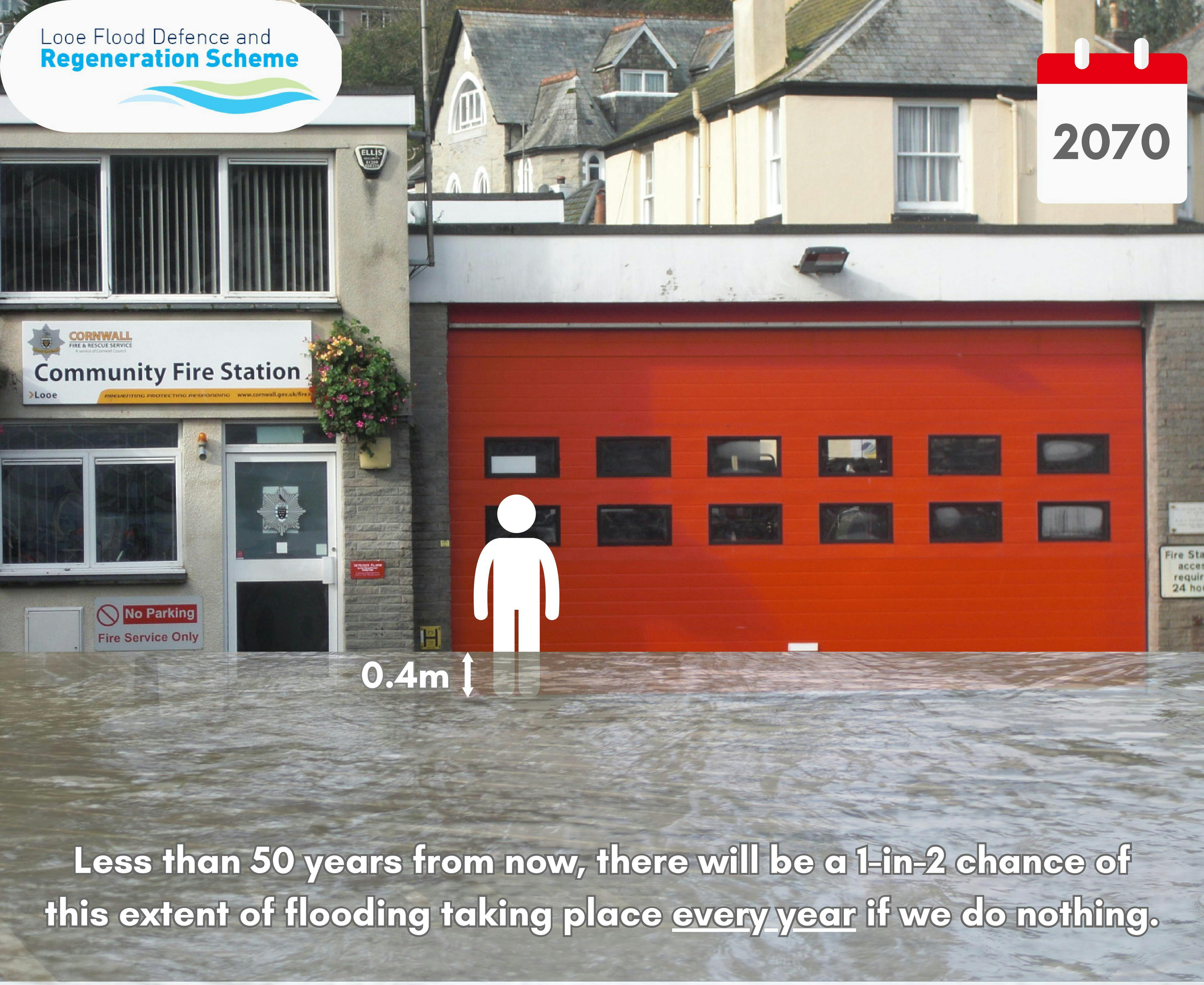
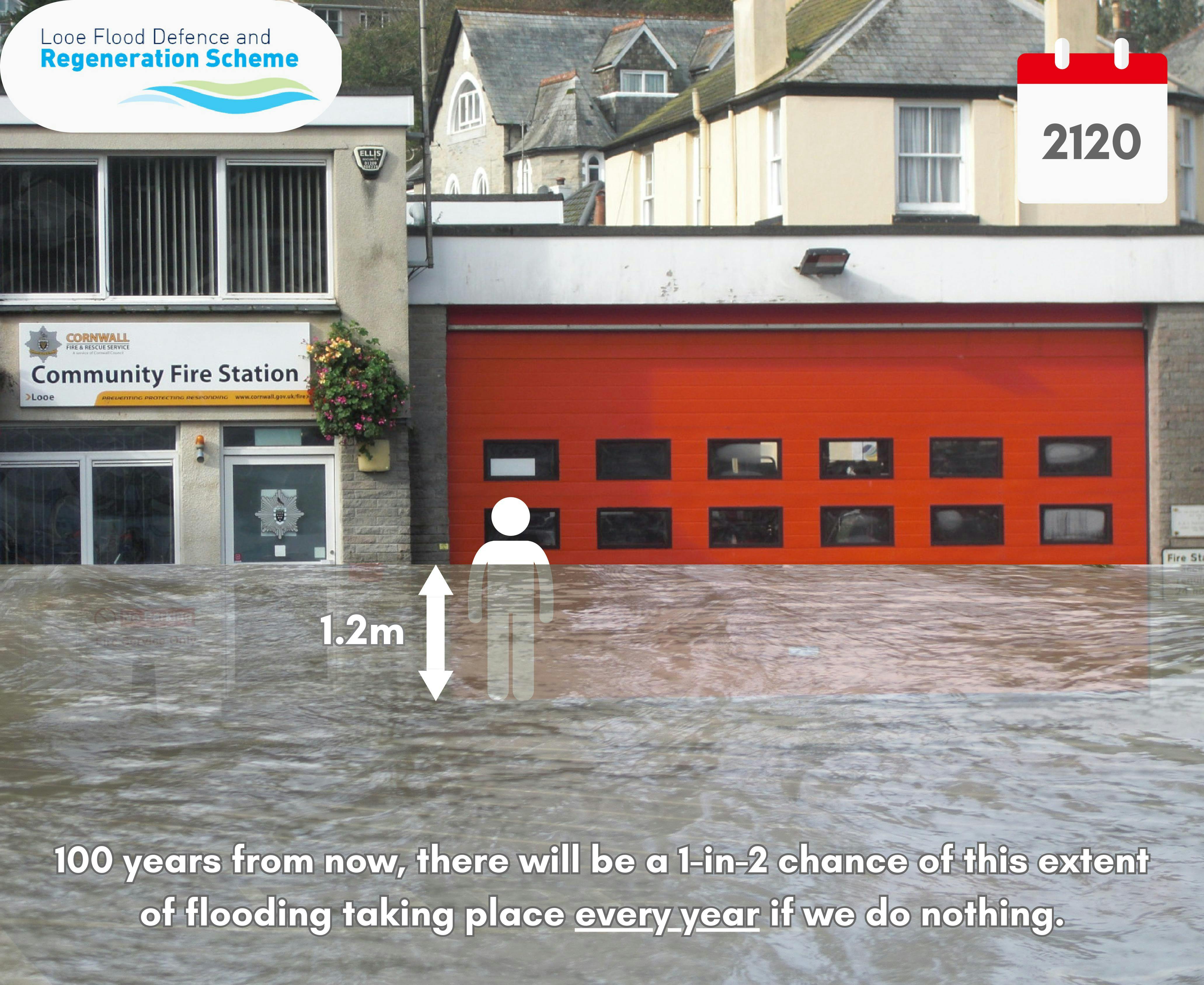
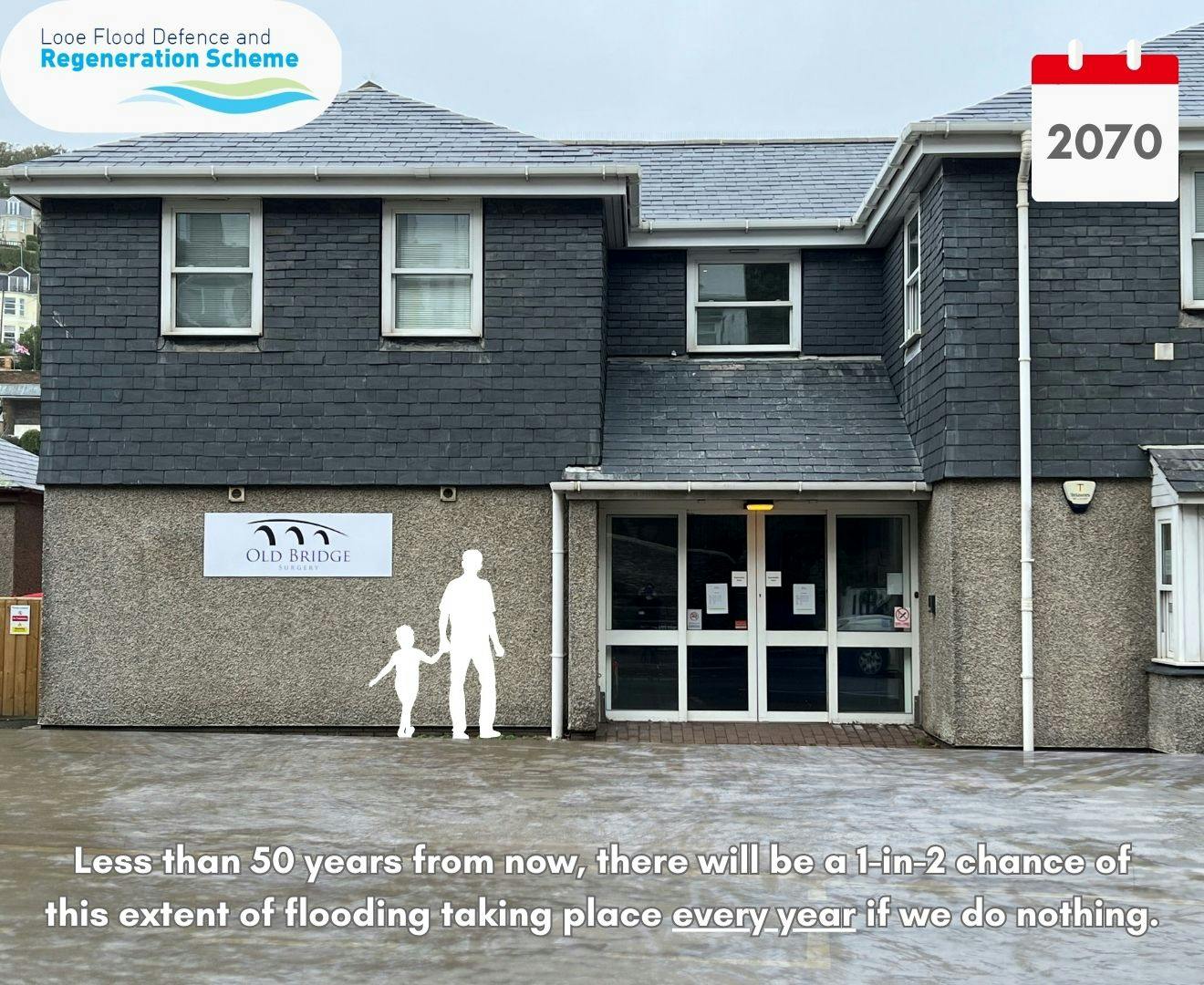
Check out this latest animation showing how flooding will affect Looe in 2070.
Stop press……
The Environment Agency have introduced a new way to make it quicker and easier for people to talk to them about flood risk – if you have a smart phone you can now use a QR code or send a text message to contact them.

About the Looe Flood Defence and Regeneration Scheme
The unique geographic features of Looe already make the town vulnerable to flood events. Sea levels are projected to rise more rapidly due to climate change, increasing the extent, depth, and frequency of flood events.
Urgent action needs to be taken to reduce the extremely high risk of further coastal flooding and erosion in Looe.
The main aims of the proposed Flood Defence and Regeneration Scheme are to:
- Protect Looe from frequent and severe flooding and damage over the next 50 – 100 years, giving the community time to adapt to a changing climate
- Enhance the environmental integrity of the designated sites and water bodies
- Work to promote economic growth in East Cornwall by
- Protecting key transport links
- Protecting and enhancing the visitor and marine economy
By delivering a scheme which reduces the risk of flooding, attracts widespread support, secures all the necessary approvals and permissions, and is capable of being funded, we can protect homes, businesses and key transport links in and around the town, at the same time as enhancing the marine and visitor economy.
This is a major project which will have a significant impact on the town.
A number of different options have considered as potential solutions during the past 20 years. Following detailed consideration, only one – the tidal barrier scheme – was considered viable.
In July 2015 Looe Harbour Commissioners funded work to develop proposals for a new food defence scheme. The outcome was supported by 95% of local residents and landowners.
in 2020 Cornwall Council’s Cabinet agreed to support the development of the Looe Flood Defence project, allocating £2.3m from the South-East Cornwall Regeneration Programme.
In 2021 the project was awarded a £2.3 million Defra Flood Defence Grant in Aid grant. This is being used to complete work on preparing the outline business case– the next key stage in securing the Government, and other sources of funding, needed to deliver the scheme.
The scheme is being led by Cornwall Council and the Environment Agency. The partners are also liaising with a number of local organisations, including Looe Harbour Commissioners, Looe Town Council, Looe Development Trust, West Looe Town Trust, East Looe Town Trust, the RNLI and local MP Sheryll Murray to turn the proposals into an economically viable and environmentally friendly solution to the town’s tidal flooding challenges.
There was overwhelming public support for the proposals put forward by the Harbour Commissioners in 2015 and we want to work with the local community to shape the final scheme.
You can view a short film about the scheme below:
Current Timeline
- Completion of Outline Business Case Spring 2024
- Funding decision 2024
- Detailed design 2025
- Harbour Revision Order Application 2025 - 2026
- Planning Approval 2026
- Construction 2026 / 2029
You can give us your views on the proposals on our discussion forum. You can also email us at LooeFloodDefence@wsp.com
Your experiences of flooding in the area
We want to hear your experiences of flooding in Looe to help shape our plans – you can share your experiences and learn about the experiences of others.
-
Share Princes Street Flooding on Facebook Share Princes Street Flooding on X (formerly Twitter) Share Princes Street Flooding on Linkedin Email Princes Street Flooding link
Princes Street Flooding
Dear Sirs.The widespread flooding that was experienced last week was also affecting Princes Street in Looe.
One of the neighbours had remarked that the water was the farthest they had ever seen it come, which was as far as their flood gate in Princes Street They have apparently lived here many years.
This encroachment up Princes Street will surely only get worse as time goes by, affecting the residences up this street as well as the surrounding businesses and other streets.
The Spar also had to close due to a power cut. I also experienced a power outage to... Continue reading
 1 comment
-
Share Serious Concerns from Residents on Facebook Share Serious Concerns from Residents on X (formerly Twitter) Share Serious Concerns from Residents on Linkedin Email Serious Concerns from Residents link
Serious Concerns from Residents
I am writing on our own behalf and also on behalf of many of the residents in Hannafore Road as we have a lot of concerns about the proposed project. Our row of Victorian properties are directly above the proposed work area and we would all like reassurances that the vibrations from the project will not damage either our properties , the banks below, or any of the unstable areas along Hannafore Road which have already experienced landslips on several occasions.
We are also very concerned about the noise and air pollution we will suffer for the several years the... Continue reading
-
Share Newsletters on Facebook Share Newsletters on X (formerly Twitter) Share Newsletters on Linkedin Email Newsletters link
Newsletters
I'm looking for the newsletters about this project. I understand there was one published in Aug '21 and another is just published (Nov'21).Where can I find them?
 1 comment
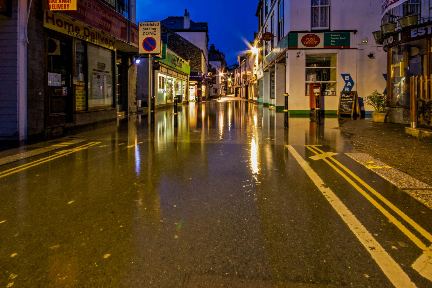
Flooding in Looe Town Centre

Key Documents
-
 Briefing Note for Save Banjo Pier flood defence option .pdf (297 KB) (pdf)
-
Looe FDS_SBP Option_Assessment.pdf (11.7 MB) (pdf)
-
Update on Looe Flood Defence and Regeneration Scheme .pdf (106 KB) (pdf)
-
Looe Flood Defence newsletter 7 .pdf (303 KB) (pdf)
-
Looe Flood Defence Scheme Engagement Round 4 Report .pdf (6.44 MB) (pdf)
-
Local community urged to have their say on Looe Flood Defence and Regeneration Scheme .pdf (92.8 KB) (pdf)
-
LooeFDS-Environmental Options Report_FINAL_issued (Jul-23).pdf (2.87 MB) (pdf)
-
final consultation event press release .pdf (122 KB) (pdf)
-
JUly 14 final engagement event poster.pdf (699 KB) (pdf)
-
Looe July 14 flyer.pdf (650 KB) (pdf)
-
Looe June consultation events leaflet.pdf (513 KB) (pdf)
-
June consultation events for Flood defence and Regeneration scheme .pdf (133 KB) (pdf)
-
Looe Boards_June Scheme Objectives.pdf (2.91 MB) (pdf)
-
Looe Boards_June Options.pdf (9.01 MB) (pdf)
-
Looe Boards_June Demountable Barriers.pdf (6.07 MB) (pdf)
-
Looe Boards_June Permanent flood walls.pdf (5.88 MB) (pdf)
-
Looe Boards_June quayside extension.pdf (5.9 MB) (pdf)
-
Looe Boards_June Tidal Barrier only.pdf (5.72 MB) (pdf)
-
Looe Boards_June Community Adaptation.pdf (1.52 MB) (pdf)
-
Looe Boards_June Tidal Barrier with Banjo Pier extension and breakwaters 1.pdf (4.85 MB) (pdf)
-
Looe Boards_June Tidal barrier with Banjo Pier extension and southern breakwater 2.pdf (8.57 MB) (pdf)
-
Looe Boards_June Carry on as we are doing.pdf (8.85 MB) (pdf)
-
Looe Boards_June Economic Regeneration.pdf (2.84 MB) (pdf)
-
Looe Boards_June environment 1.pdf (5.55 MB) (pdf)
-
Looe Boards_June Environment 2.pdf (5.95 MB) (pdf)
-
Looe Boards_June Environment Options Appraisal.pdf (49.6 KB) (pdf)
-
History of Flooding in Looe April 2023.pdf (996 KB) (pdf)
-
Aims and Options Looe Flood Defence and Regeneration scheme .pdf (862 KB) (pdf)
-
Options for Looe Flood Defence and Regeneration Scheme.pdf (1.48 MB) (pdf)
-
Banjo Pier proposals .pdf (660 KB) (pdf)
-
Environment.pdf (550 KB) (pdf)
-
Economic regeneration article .pdf (431 KB) (pdf)
-
Looe information sharing events poster.jpg (796 KB) (jpg)
-
workshops events for Looe Flood Defence and Regeneration Scheme.pdf (105 KB) (pdf)
-
Engagement report January 2023.pdf (9.53 MB) (pdf)
-
update on October 2022 Looe Flood Defence scheme engagement events.pdf (659 KB) (pdf)
-
Looe-FD-engagement-slides-October-2022.pdf (28.9 MB) (pdf)
-
Looe Flood leaflet final WEB.pdf (1.46 MB) (pdf)
-
Looe Flood Defence Newsletter 3.pdf (937 KB) (pdf)
-
Looe Flood Defence Newsletter edition 2.pdf (246 KB) (pdf)
-
Looe Flood Defence scheme engagement report.pdf (6.12 MB) (pdf)
-
Looe Flood Defence Newsletter 4 - Feb 2022.pdf (378 KB) (pdf)
-
Looe newsletter edition one.pdf (555 KB) (pdf)
-
Looe Flood Defence and Regeneration Scheme Presentation.pdf (3.55 MB) (pdf)
-
Looe Flood Defence and Regeneration Scheme Flyer.pdf (388 KB) (pdf)
-
Looe residents and businesses invited to shape Flood Defence and Regeneration scheme.pdf (578 KB) (pdf)
-
Looe Flood Defence Newsletter July 2022.pdf (431 KB) (pdf)
-
Looe residents and businesses invited to hear latest update on Flood Defence and Regeneration Scheme .pdf (364 KB) (pdf)
-
More flooding in Looe affects homes, businesses and transport links.pdf (887 KB) (pdf)
-
Plan of land.pdf (2.35 MB) (pdf)