
Looe Valley Trails
This page is no longer updated.
Looe Valley Trails: creating a network of multi-use trails linking Liskeard, Looe, Bodmin and the Rame Peninsula
Latest News
The first stage of the Looe Valley Trails project – to develop concept designs for all three routes and produce a strong business case to support bids for the funding needed to deliver the final scheme – has been successfully completed.
We would like to thank everyone who has been involved with the project for their contribution to our work and studies.
Whilst completion of this first phase marks a significant milestone for the project, work on the next stage – engaging with landowners, resolving any outstanding alignment issues and consulting with the local community – and then subsequently delivering the final scheme is dependent on securing further funding from central Government.
Key to that delivery will be the continued support of the local community and stakeholders.
About the project
Looe Valley Trails is one of a number of schemes being developed by Cornwall Council in partnership with other stakeholders to support the economic regeneration of South East Cornwall.
The project will provide a network of tracks connecting Looe, Liskeard, Bodmin and Cremyll, creating over 80 kms of multi-use trails for residents and visitors to walk, bicycle and ride and opening up access to some of the most beautiful and distinctive landscape in Cornwall.
The original brief from Cornwall Council was to develop the initial designs for the routes and to produce an outline business case for the project. Both these tasks have now been completed.
The project team have worked hard to find the right balance between protecting the environment and encouraging people to get into their local, natural environments and improve their health and wellbeing, and supporting economic regeneration.
This has involved liaising with town and parish councils, community groups and stakeholders to design routes to minimise, wherever possible, any negative effect on residents and the environment.
Aims of the project
The specific aims of the project include:
- Providing inclusive and high-quality multi-use routes which support active travel and improve the health and wellbeing of the local community
- Supporting new business opportunities, such as cycle hire operators and cafes, to boost the local economy, secure existing jobs and encourage job creation
- Encouraging increased tourism and visitors to the area and maximising spend in the local economy by trail users
- Improving the safety and journey ambience of active travel trips in the area
- Improving active travel connectivity between the four major settlements (Looe, Liskeard, Bodmin and Cremyll), and increasing access to local facilities and services
- Improving resilience and reducing congestion on the road network in Looe, and addressing overcrowding of the train service on the branch line
- Improving the area’s resilience to climate change.
- Increasing the number of visitors during the low season
- Ensuring the scheme safeguards and enhances the natural and historic environment, achieving a net gain in biodiversity and canopy cover and reduced carbon emissions, and connecting residents and visitors with the heritage and nature of the area, supporting the Forest for Cornwall and Local Nature Recovery Network programmes.
Current position
During the past 18 months the project team have worked with partners, stakeholders and the wider public to develop concept designs for all three routes. These develop route designs from a ‘line on a plan’ into more tangible schemes. As well as identifying recommended routes for the trails, including on and off-road sections, the designs include suggestions for stopping places, pedestrian and cycle crossings, signage and areas for bike parking.
A Design Panel comprising representatives of partners and the local community, was created last year to help shape the designs. This led to positive changes to some of the original proposals which have been included in the current designs.
These include moving a section of the proposed Liskeard to Looe route from the East Looe river valley to the West Looe river valley, reducing the potential impact on the environment, and providing an off-road section in the Tregantle Fort area on the Looe to Cremyll route following concerns over high traffic volumes and speeds from motorised users.
Some preliminary work has also been carried out on the potential to create a link with Lostwithiel. Initial findings show that, as the majority of this section could be provided on existing roads and public rights of way which are already paved, it would only require a very short section of new path to be constructed to create the link.
At the same time work has been taking place to develop the business case to support bids for external funding to deliver the scheme.
The completion of the concept designs and the business case means that the schemes are in a strong position to be progressed if further funding can be secured.
Concept designs
The designs for all three routes contain a mix of on and off-road sections. Where possible the on-road sections are on quiet roads and country lanes.
While the project has been developed as a single scheme, the designs allow for the routes to be delivered in phases if required. These could enable individual sections, such as the Looe to Cremyll route and the Liskeard to Looe Loops, to be delivered ahead of more complex and potentially more costly sections if individual pots of funding became available.

Looe to Bodmin route

While the majority of this 17.1km route is on-road, these sections are mainly located on quiet roads, country lanes and existing Forestry Commission tracks, with an off-road section linking to Bodmin Parkway.
The section at the east of the route also co-incides with the Looe to Liskeard route.
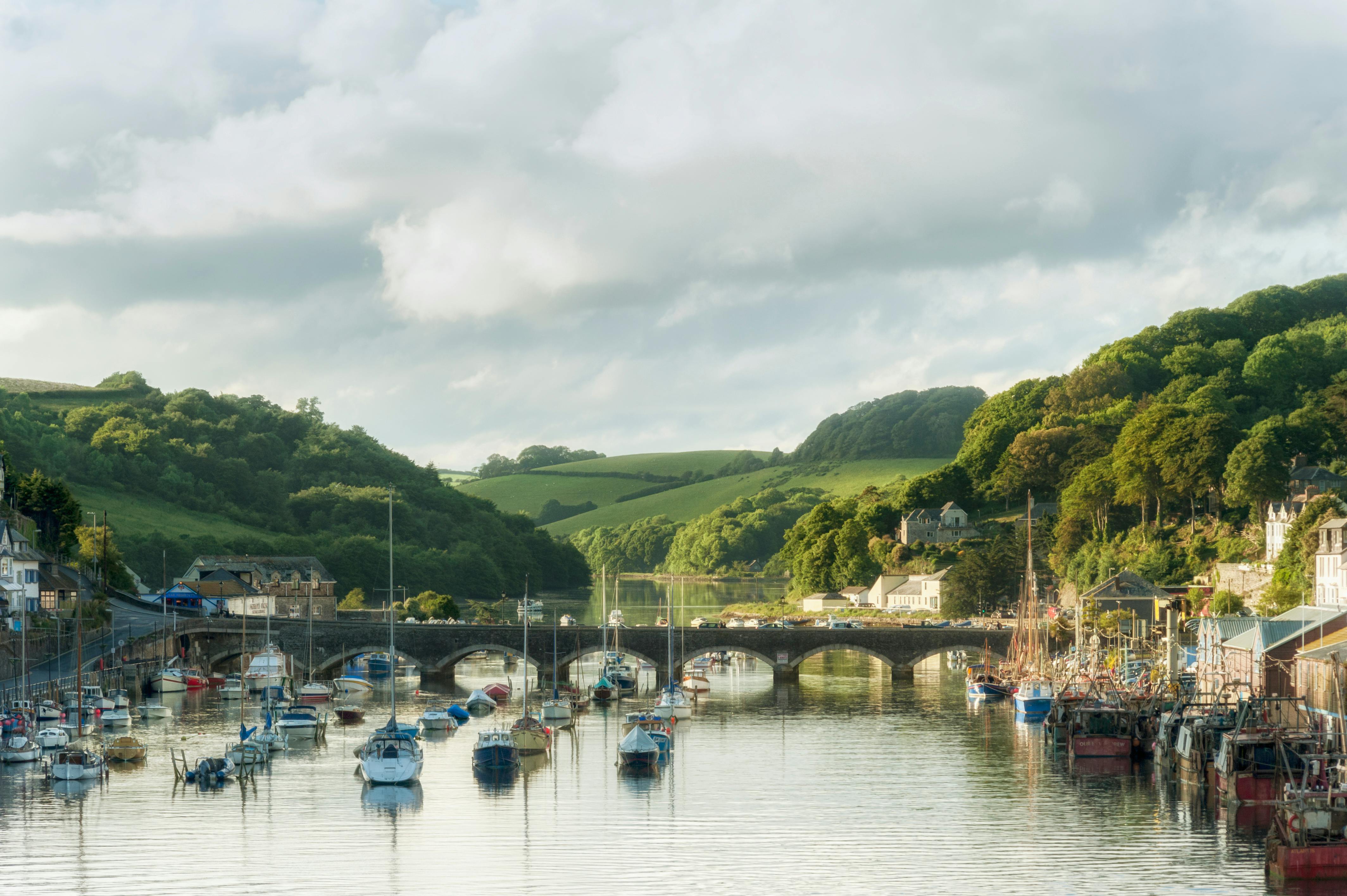
Looe to Liskeard route

This 31km route is a combination of largely traffic free sections, with a linking section on quiet country lanes. It has been designed to fit alongside the new cycling hubs and other sustainable transport links which are being developed by others in Looe and Liskeard.
The route includes two high quality loops which provide a circular route. Discussions with landowners and the local community have led to some changes in the alignment around the Liskeard loop to prevent users having to access a busy road and also to address environmental concerns. As a result the route now goes through the West Looe river valley rather than the original proposal which to go through the East Looe river valley.
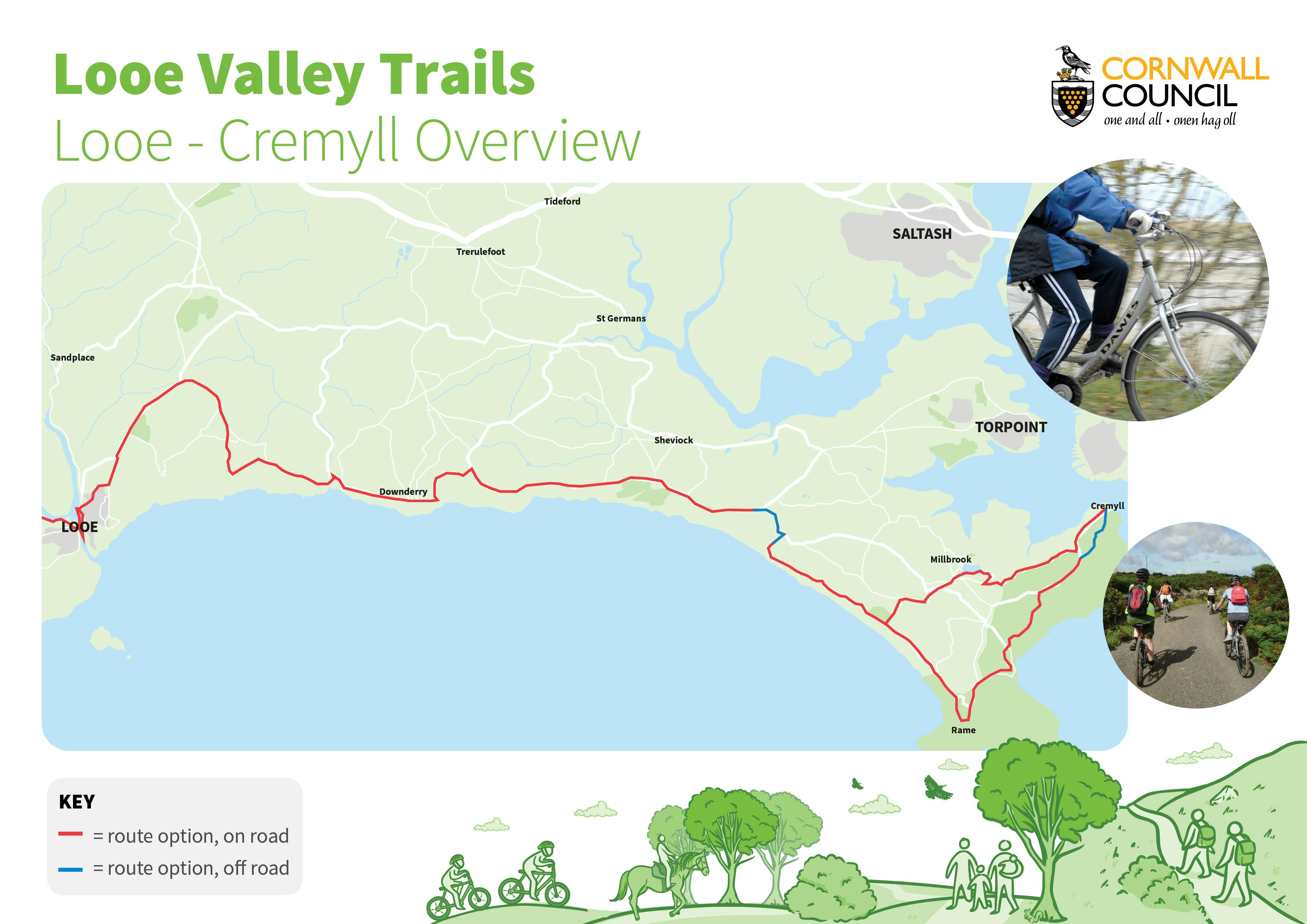
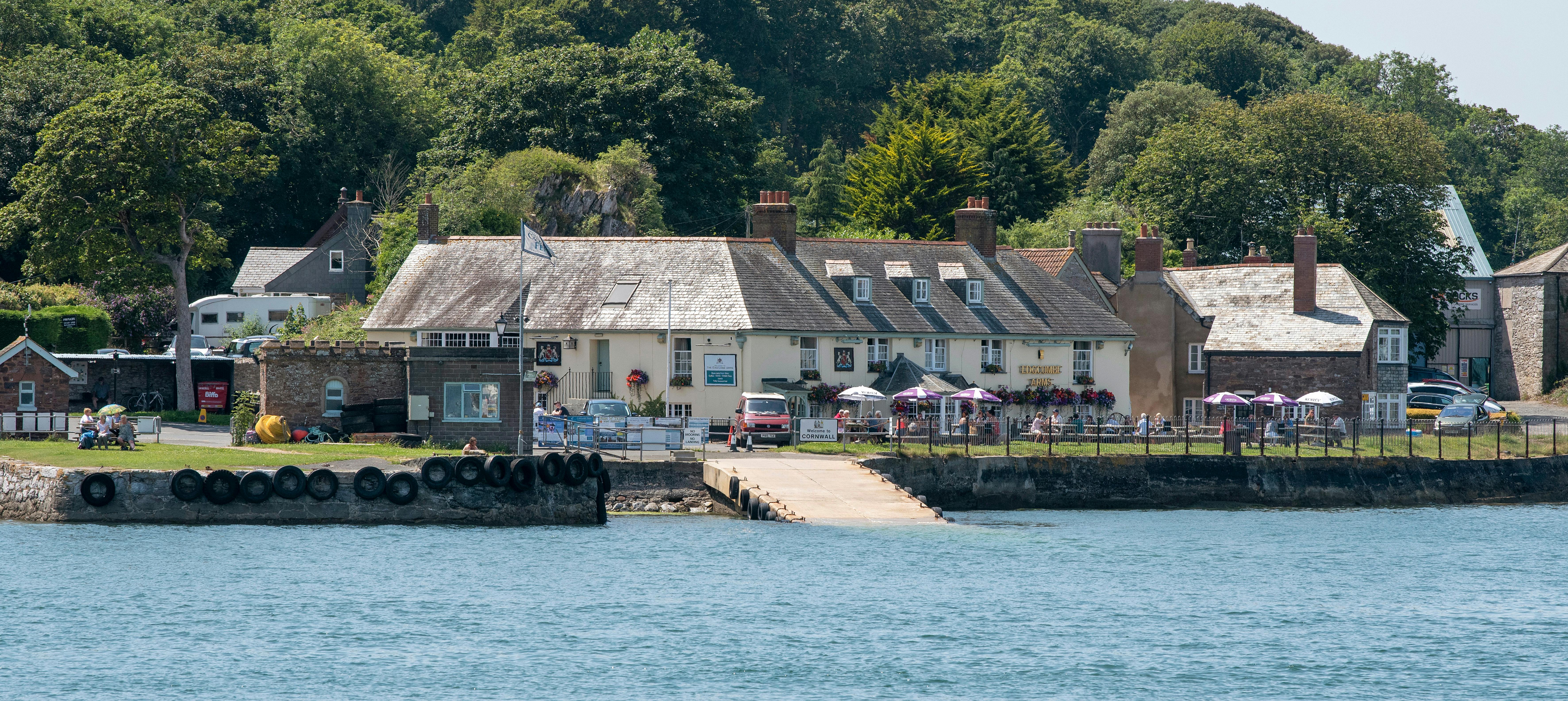
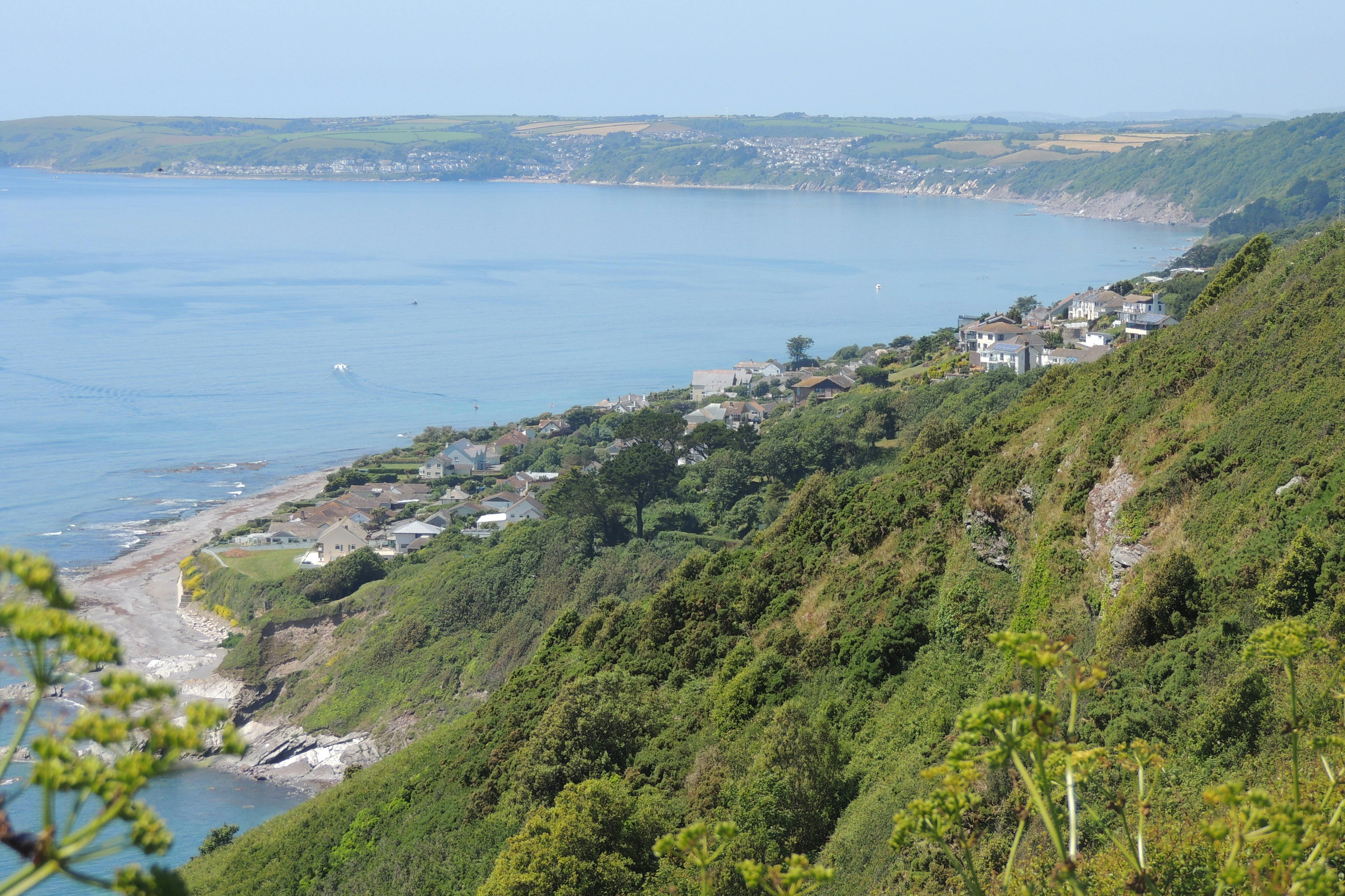
Looe to Cremyll route

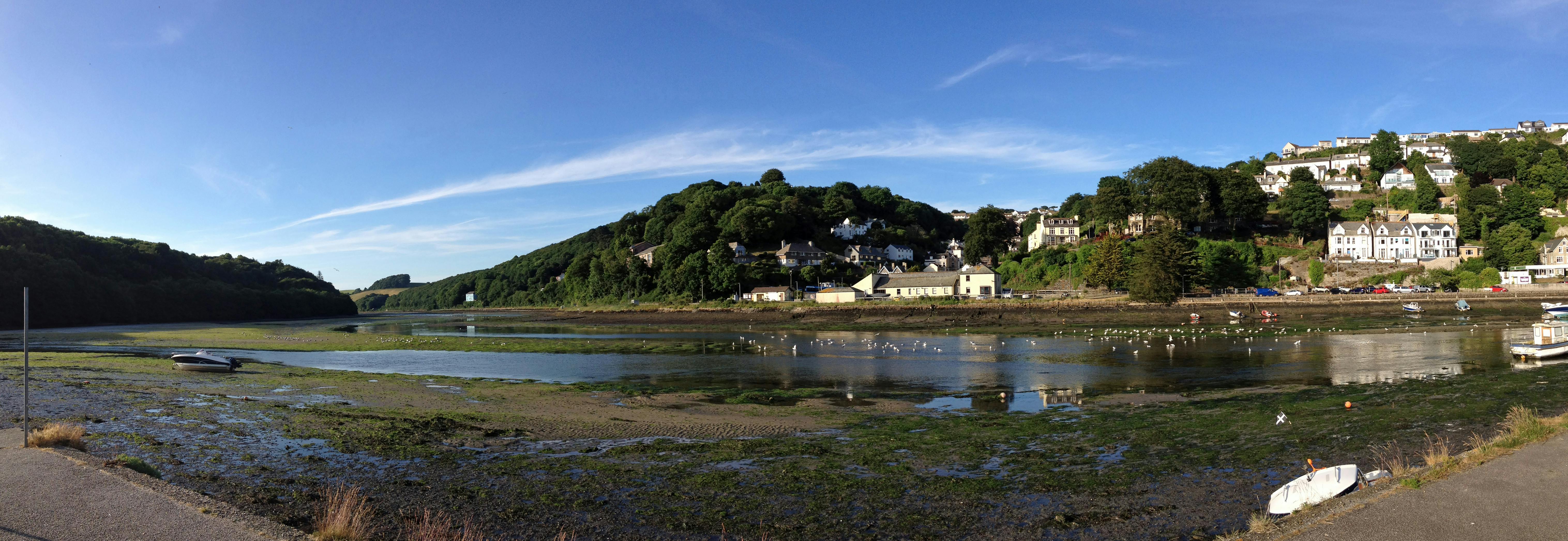
This route covers a distance of around 32km between Looe and Cremyll, covering the main population centres of Downderry, Seaton, Portwrinkle, Crafthole and Freathy along the way.
Linked to the promoted National Cycle Network from Plymouth, this section, which begins at the Millpool car park in Looe, is mainly on road, with an 8km on-road loop at the Cremyll end of the route which provides a waymarked route connecting the settlements in the Rame area and completes a gap in the existing promoted cycle network.
Following concerns from the local community over high traffic volumes and speeds from motorised users, there is now an off-road section in the Tregantle Fort area which provides a new path adjacent to the B3247 from the junction from Anthony Hill all the way round to Military Road. This also provides a safe pedestrian route at all times, closing the gap in the coast path at times when the MoD need to close the route that crosses their land.
Next steps
Work on developing and delivering the next stage of the project is dependent on securing further funding. Discussions will be held with key partners to identify future funding opportunities.
Further updates will be provided as required.
Documents
-
 LVT Design Panel
-
Newsletters
-
 Looe Valley Trails Newsletter issue 2.pdf (1.02 MB) (pdf)
-
new chair and vice chair of Looe Valley Trails design panel.pdf (123 KB) (pdf)
-
Looe Valley Trails Newsletter_Issue 3_.pdf (2.26 MB) (pdf)
-
Public invited to have their say on proposed Looe to Cremyll trail .pdf (380 KB) (pdf)
-
Looe Valley Trails Leaflet_web.pdf (1.29 MB) (pdf)


Frequently Asked Questions
-
Project Development
- What progress has been made so far?
- When will more information be available about the project? How can I see it?
- Why has the proposed route changed from the work that was completed by the Looe Development Trust?
- What is the Looe Valley Trails project?
- What is a multi use trail ?
- Where did the idea for a network of multi use trails originate ?
- Are the routes already decided?
- What are the aims of the project?
- Who is involved in the project?
- Are the trails part of a package of complementary projects?
- What does the project include?
-
Environment
- Many of the areas that the trails pass through have rarely seen humans, how can you safeguard the environment when you are putting humans into these places?
- Why can’t you just close the Looe to Liskeard branch line and use this as a cycle trail?
- The EIA screening opinion says that a full EIA is not required, how are you going to protect the environment?
-
Communities and Participation
-
General Queries
- Will I be compensated for use of my land or disruption to my business etc?
- What commitment towards the trails development has the Council offered?
- Why has it taken so long to get information about the trails communicated
- Can I ride my horse on the trails when created?
- Why has a planning application been submitted prior to engaging with the communities?
- How will the trails be maintained once they are in place ?
- Why is it taking so long to develop the project?
- I am concerned that motorbikes will use the trails and create an unsafe environment, what are you doing to prevent this from happening?
- Will there be a bridge across the West Looe River to Trenant Point?
- Why can’t cyclists just use the roads and not spend the money on them?
- Will you be providing Motorhome/Campervan parking as part of this project? And will it be overnight parking provision?
Videos
-
 Interviews with Chair and Vice Chair of Looe Valley Trails Design Panel
-


Friends of Kilminorth Woods, a local environmental group, is increasingly concerned at the support being given by local decision makers to the development of a series of cycle trails centred on Looe, and in particular, the pinning of future developments (such as a Cycle Hub, and harbour extension) on what is currently a vague proposal, and which if carried through will negatively affect the environment.
We have yet to be re-assured by the answers to queries we have been raising since the project was first mooted, both concerning the SE Cornwall project as a whole, and specifically about the proposed route through Kilminorth Woods.
The Aim and Objectives of the Project.
The aim appears to be to create multi-use trails in order to attract additional tourists (500,000 a year) and to benefit local people both directly (with increased leisure facilities, for commuting) and indirectly (through economic development).
We think insufficient attention has been given to the disadvantages inherent in these objectives.
Multi-use.
Multi-use trails attracting large numbers of people of different abilities will inevitably lead to conflict between users. Walkers, cyclists and horse riders do not mix easily. Elderly walkers may not hear cyclists, cyclists may be interrupted by dogs, young families may feel unsafe meeting speeding or motorised vehicles.
Additional tourists.
Popular tourist spots throughout the world, including parts of the UK, are recognising that there is a limit to their carrying capacity. There were moves in the summer of 2021 to declare Cornwall “full”. The attractiveness of such places is reduced, and the damage to the environment can become severe.
Direct disadvantages to local people.
This may lead to a reduction of recreational amenities for local people, through being “pushed out”, or through reduced enjoyment. And surely, only an extremely small number of local people will find the proposed trails useful for commuting or shopping trips.
Indirect disadvantages to local people.
Any economic benefits of increased visitor numbers will be more than offset by increased pressure on scarce resources and local services – such as roads, water, housing, parking, waste collection, health services - and SPACE. There will be increased pressure on an already fragile natural world, which in turn impacts on the human population.
The Proposed Routes.
Access to Looe. Situated on the Looe estuary with a backdrop of the two wooded river valleys, the geography of Looe contributes to its attraction. But this geography inevitably means that access to the town can be difficult, involving steep slopes and river crossings. For this reason, any hopes of constructing a multi-use cycle trail culminating in Looe should first solve this access problem before attempting to plan or construct any routes to Liskeard or elsewhere. Major, and expensive, engineering work could be involved.
Use of roads.
Routes proposed so far will make substantial use of existing roads, including narrow winding lanes and busy highways. This will be dangerous for all road users. National guidelines (LTN1/20) are opposed to using roads for cycle trails, unless it is just a very short section linking longer sections of dedicated cycle tracks.
Kilminorth Woods section. Practical problems.
The proposed trail follows an existing path which on a map might seem an obvious choice. However, when assessed against national guidelines (LTN1/20) there are significant concerns that suggest this route is not suitable for a multi-use trail.
Access points.
Entrance gates would need to be removed to allow free access to the trail. Motor cycling is not permitted in this Local Nature Reserve, and currently there is gated access into the woods, in an attempt to discourage this. (There have been problems with motor bikes in the past.) How would motor cycles be excluded?
Steep gradients.
There are several sections with very steep gradients, making the route unsuitable for many within the anticipated multi-use group. The amount of construction work needed to reduce gradients would create considerable disturbance to the woodland.
Pinch points.
Similarly, there are a number of narrow pinch points where for safety reasons the existing path would need to be widened. This would involve removing trees and banks. This is complicated further in that much of the current track closely follows the route of the Giant’s Hedge ancient monument.
Sight lines.
Improving poor sight lines around bends would require removal of trees.
Vertical structures.
Trees growing close to the track are deemed hazardous and would need to be removed.
Steep drops.
There are steep drops alongside the track. This may mean bringing in material to infill and further widen the track, and/or building fences.
Surface.
The surface of the current track is not suitable for cycle traffic. Any introduced materials would need to be porous to cope with heavy rainfall, and guaranteed not to impact on the soils/flora/fauna of the ancient woodland. Run-off from heavy rain could still accelerate erosion of steep slopes, removing soil from the woodland and adding to deposits in the river.
Removal of leaves.
There is an expectation that leaves should be removed from a cycle track. A route through deciduous woodland such as Kilminorth would require road sweeping several times a year. Presumably if this is not carried out sufficiently there could be insurance claims in the event of accidents. So the surface would need to be robust enough to carry a road sweeping vehicle.
Combined use.
The path through Kilminorth Woods is already popular with walkers including dog walkers. LTN1/20 suggests that cycle traffic should be separated from pedestrian and equestrian traffic where conflict can be anticipated. Closing the current path to pedestrians would be very unpopular, as would requesting dogs to be kept on leads. Additional pedestrian paths might need to be constructed. Dogs could still run onto and along the trail; any fences constructed to prevent dogs accessing the cycle trail would seriously affect mammal movements throughout the woods.
Kilminorth Woods section. Environmental concerns.
Value of the LNR.
The ancient woodland has been of value to the local population for hundreds of years. Once a source of timber, it now provides a quiet refuge, away from the noise of traffic and town, notably throughout the hectic summer months. Especially during the last few years, so many people have come to rely on walks in the woods to maintain their mental health - restoring, calming, reducing stress levels. But even more, healthy woodlands are a vital part of our fight against climate crisis and environmental collapse.
Construction and maintenance.
Currently, maintenance is about ensuring the woodland is a healthy natural habitat, and sufficiently safe for users. It is clear that construction of a cycle track and its on-going maintenance will be noisy and intrusive, damaging the woodland for both wildlife and people.
Visitor numbers.
Responsible management of the woods has to include recognising that there has to be a balance between the needs of the natural environment and the demands of the human population.
Anti-social behaviour.
Littering, lighting fires, camping, riding bikes off-track, vandalising fences, all currently occur in the woods. Friends of Kilminorth Woods support the CORMAC Ranger to try to minimise the effects on the woodland. Although only a small minority of current users are responsible, their actions damage the environment and reduce the general public’s enjoyment of the woods. The cycle trail, encouraging large numbers of people into the woods, is bound to increase these problems, as well as introducing noise, putting additional stress on this fragile habitat.
Disturbance.
Disturbance is key. Wildlife needs space, with minimal human impact, in order to thrive. Increased disturbance poses a threat.
Any development proposals which could have even potential negative impacts on the existing natural environment, should not be allowed to go ahead.
Kilminorth Woods section. Public benefit.
The woods are maintained as a nature reserve and for the benefit of the public. But the benefit to the public lies in the reserve being a secure home for nature. Nibbling away, with a little development here and a little more disturbance there, risks eventually undermining the whole fragile ecosystem. As it gradually becomes degraded, so does its work of protecting soils, storing carbon, purifying air, contributing to our own physical and mental well-being. Its ability to provide a safe haven for a wide variety of flora and fauna becomes diminished: its public benefit becomes diminished.
Summary:
Friends of Kilminorth Woods cannot support the current proposals for cycle trails.
Re: Looe - Cremyll Route. It is very difficult to make out the route from the map provided on the website. Please can a better map of the route be provided in order to allow us to comment, as you are requesting.
I have concerns about the safety of cyclists on the narrow roads that seem to be included in the route. As a driver, I often encounter traffic going too fast in the opposite direction on the narrow/winding sections. I am concerned for the safety of cyclists who find themselves in the path of these vehicles. Neither do I like the idea of having to slow down to cyclists' speed on journeys because of the difficulty of passing cyclists on these same roads. At the projected 500,000 extra cyclists per annum this could be most/all journeys. (An off-road track on the seaward side of the B3247 road hedge could work in some places - even better with a wild flower strip on the seaward side of the track - but this would be expensive in a time of cash shortage.) If the route into Looe is Shutta Hill, this is residential especially at the bottom and extremely steep. I do not think that residents on foot will feel, or be safe, if cyclists are encouraged to use this route - some cyclists are bound to go too fast. I have found that it is not possible to relax as a pedestrian even on a flat multi use trail.
If we had a ready-made route, like the disused railway track for the Camel Trail, I would welcome the opportunity to cycle in this part of Cornwall, but we don't. People can already get out to explore the countryside on foot, using our beautiful footpaths, without the need to widen or straighten or flatten routes all at the risk of destroying the things that people currently enjoy. I really think that public money would be better spent elsewhere, especially now.
I understand the aim of this project is to mirror the success of the North Cornwall cycle links, including the Camel Trail, which attracts more than 500,000 visitors a year to the local area. I do believe however that comparisons with the Camel Trail, an abandoned railway line which is relatively level, safe and family friendly, should be made with caution.
The terrain around Looe, the area I am interested in, is hilly and difficult for all but competent and reasonably athletic cyclists and the proposed routes are sometimes potentially hazardous or pass through locations with a high environmental sensitivity such as Kilminorth Woods nature reserve and the West Looe river valley.
Much as I would like to support cycling locally, I question whether Looe has the appropriate geographical characteristics to ever become a successful and viable cycling destination and the public money spent trying to promote the idea would be better used elsewhere.
You are conducting a survey by inviting folk to 'Have your say on the recommended Looe to Cremyll route' but I can't find adequate detail of the roads being used. As you know from my previous query in October, I am interested in the route(s) out of Looe.
Hi, You say that details of the Looe to Cremyll route and potential enhancement opportunities are now available for comment. I’d like to provide feedback but the map provided does not appear to have any detail of the route(s) out of Looe. Where does it start and does it go up the hill of St Martin’s Road or up the Shutta or the Coastal path via the Wooldown or some other route?
Where possible, please separate cyclists from pedestrians, it is a nightmare walking with dogs where cyclists are whizzing by. We need spaces where welll behaved dogs can run and have some freedom. It’s not reasonable to develop facilities then only allow dogs on leads, whilst giving priority to cyclists. Im very excited about the project and look forward to walking on these routes. I hope there will be poo bins and a good cafe on route.
I'm supportive of the project and objectives it hopes to meet, I would like to see more off-road provision considered and proposed as young families with cycles/ strollers, dog walkers with multiple pets, groups of cyclists or runners for example do not have the facillity to alway mount a hedge to make way for passing traffic on narrow rural lanes. The safety considerations that extend to the A390 section and the more established routes will have to be supported effectively due to the speed and consideration (or lack of) that some road users exibt on these stretches of road if the investement in the project is gong to be valid and ultimately used by locals and visitors.
The idea of ‘multiuse trails’ sounds very good when applying for funding but in real life they really don’t work. As a mother of a horse riding daughter I know that horses hate bikes as they rush up behind them with no warning often causing horses to spook or bolt which can be very dangerous for riders. My husband and I are keen walkers often with the grandchildren but when walking on tracks or paths also used by bikes you can’t ever relax as you have to be constantly watching out in front and behind for bikes to ensure the kids or dogs don’t step out in front of a bike which could be lethal! On the other hand we do like cycling on dedicated bike trails with the grandkids especially if the trail is nice and flat with few inclines. I really think multiuse trails should be avoided on safety grounds.
So much of the trail appears to be on the road (the red route option). As a rambler and dog walker this is not very usable for me. I know it is not easy to provide off road routes but there will be more take up of the route if there are more off road options.