Liskeard Pedestrian Improvements
Consultation has concluded
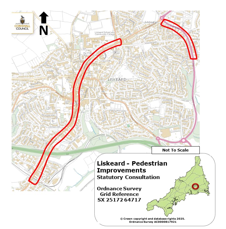
We are proposing to improve the pedestrian and cyclist experience through Liskeard town centre and Charter Way.
What are we consulting on?
We are proposing a range of improvements across Liskeard town centre to make it safer, easier, and more accessible for people walking, crossing roads, cycling, and visiting local shops and services.
These improvements include:
- Better and safer road crossings.
- Wider footways where possible.
- Measures to slow traffic.
- Improvements for visually impaired users.
- A more attractive and connected street environment.
- Shared use path on Charter Way
Liskeard Town Centre Improvements
SN01 – Grove Park Terrace and surrounding area.
- Existing crossing at Grove Park Terrace will be improved with tactile paving to help visually impaired users.
- The entrance to the Stag Inn car park will be narrowed with a build-out, creating a shorter and safer crossing, with new tactile paving and dropped kerbs.
- The junction at Miller Business Park will also be narrowed, with new dropped kerbs and tactile paving added.
SN02 – Station Road.
- The road will be resurfaced to improve its condition.
- Crossings at Carwinion Terrace and Rosemellen Terrace will be upgraded with tactile paving and dropped kerbs.
- Footways will be widened by improving kerb lines and making better use of existing build-outs and bollards to create a more continuous space for pedestrians.
SN03 – Lamellan Court and Manley Road.
- Lamellan Court entrance will be resurfaced and included within a wider footway.
- A new raised (table-top) crossing will be added at Manley Road, with tactile paving and dropped kerbs.
- The nearby crossing north of Manley Road will be improved with a better central refuge and new dropped kerbs.
SN04 – Heathlands Road.
- A new footway will be built at the entrance to Heathlands Road.
- An imprint crossing with tactile paving will be added.
- An existing crossing on Station Road will also be improved with tactile paving.
SN05 – Lanchard Lane.
- A large build-out will narrow the road, helping to slow traffic.
- The area will include improved landscaping.
- The existing crossing will be upgraded with an imprint surface.
SN06 – Russell Street.
- A new zebra crossing will be installed.
- The road will be resurfaced, with high-friction surfacing on approaches to improve safety.
- Studded tactile paving will be used to protect historic granite features.
- The crossing at the entrance to Taylors Motors will also be improved.
SN07 – Windsor Place / Bay Tree Hill.
- The side road opposite the Royal British Legion will have an improved crossing with an imprint surface.
- Footways at Windsor Place and Bay Tree Hill will be extended using suitable granite materials.
- Bollards will be added to improve pedestrian safety.
- The nearby lay-by will be reduced by one parking space to help traffic movement.
SN08 – Barras Street / Place.
- Crossings at Barras Place, Barras Street, and Pike Street will be improved.
- Road surfaces and markings will be refreshed between Barras Street and the Greenbank Road roundabout.
SN09 – Greenbank Lane and surrounding area.
- The footway on Greenbank Lane will be extended.
- A new imprint crossing with tactile paving will be installed.
- Additional crossings will be added on Tremadden Lane, and at the entrances to the fire station and community college.
SN10 – Public buildings area.
- New imprint crossings with tactile paving will be added at the entrances to:
- The County Council service building.
- The Community College.
SN11 – Double roundabouts area.
- Existing crossings will be upgraded to improve accessibility.
- The central refuge between the roundabouts will be extended and improved, including tactile paving.
- New footways and landscaping will be added on the southern side.
Charter Way Improvements
SN01 - Caradon Heights.
- New marked crossing at Caradon Heights.
- Additional crossing nearby on Charter Way.
- New crossing on Stephens Road.
- A new shared path for pedestrians and cyclists along the south side of Charter Way.
SN02 - Martins Road and surrounding area.
- A new signal-controlled crossing between Stephens Road and Martins Road, with high-friction surfacing.
- A new marked crossing with tactile paving on Pengover Road.
- The shared pedestrian and cycle path will continue along Charter Way.
SN03 - Quimperle Way.
- Improvements to the existing crossing near Quimperle Way, including a wider central refuge for pedestrians and cyclists.
- Continued extension of the shared-use path, linking with previous sections.
Why are we doing this?
These improvements are designed to:
- Make it safer and easier to get around on foot or by bike
- Improve access to local shops, services, and facilities
- Provide better crossings, especially for people with mobility or visual impairments
- Create more continuous and connected routes through the town
Next steps
We welcome all comments and suggestions regarding this proposal.
Any feedback received will be collated and considered before a final decision is made and we proceed.
🗣️ Have your say on this consultation?
Tell us what you think about our new proposals.
It’s quick, easy, and we would love to hear your feedback. Click the survey below 👇
Scheme Location
Documents
-
 Overview (6.03 MB) (pdf)
-
SN01 – Grove Park Terrace and surrounding area. (555 KB) (pdf)
-
SN02 – Station Road. (529 KB) (pdf)
-
SN03 – Lamellan Court and Manley Road. (549 KB) (pdf)
-
SN04 – Heathlands Road. (513 KB) (pdf)
-
SN05 – Lanchard Lane. (521 KB) (pdf)
-
SN06 – Russell Street. (526 KB) (pdf)
-
SN07 – Windsor Place Bay Tree Hill. (484 KB) (pdf)
-
SN08 – Barras Street Place. (555 KB) (pdf)
-
SN09 – Greenbank Lane and surrounding area. (582 KB) (pdf)
-
SN10 – Public buildings area. (552 KB) (pdf)
-
SN11 – Double roundabouts area. (619 KB) (pdf)
-
Charter Way SN01 - Caradon Heights (544 KB) (pdf)
-
Charter Way SN02 - Martins Road and surrounding area. (513 KB) (pdf)
-
Charter Way SN03 - Quimperle Way. (514 KB) (pdf)
