Colan, Newquay
Consultation has concluded
During 2019 and 2020 we undertook a review of the whole of Cornwall. The review had to be paused temporarily due to the Coronavirus Pandemic. When the review resumed, Cornwall Council was able to make final decisions in respect of most Towns and Parishes. Due to the complexity of the issues for the whole of Penzance Parish and the time constraints Cornwall Council agreed that the decisions about proposals for Penzance be deferred until after the May 2021 elections.
Since we last consulted on these deferred proposals (between December 2019 and March 2020) a considerable length of time had passed and some of the circumstances that are relevant to these proposals may have changed since then. We therefore provided a further opportunity to provide feedback on these proposals.
As no final decisions were made with regards to these proposals, we were seeking opinions on:
- the Council’s draft recommendations from December 2019 that were the subject of the last public consultation; and/or
- any subsequent recommendations that were made following the consideration of the outcome of the public consultation.
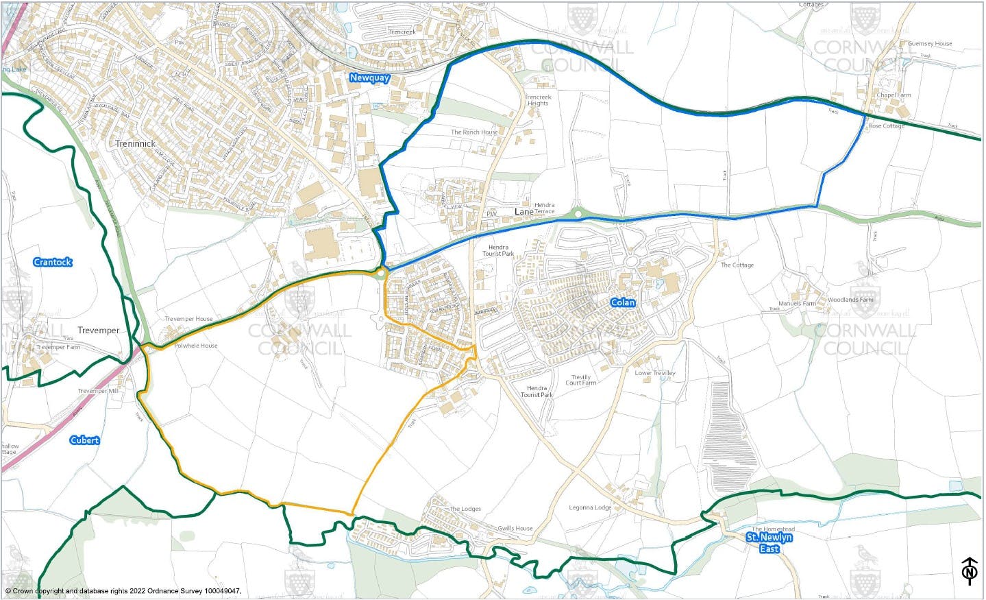
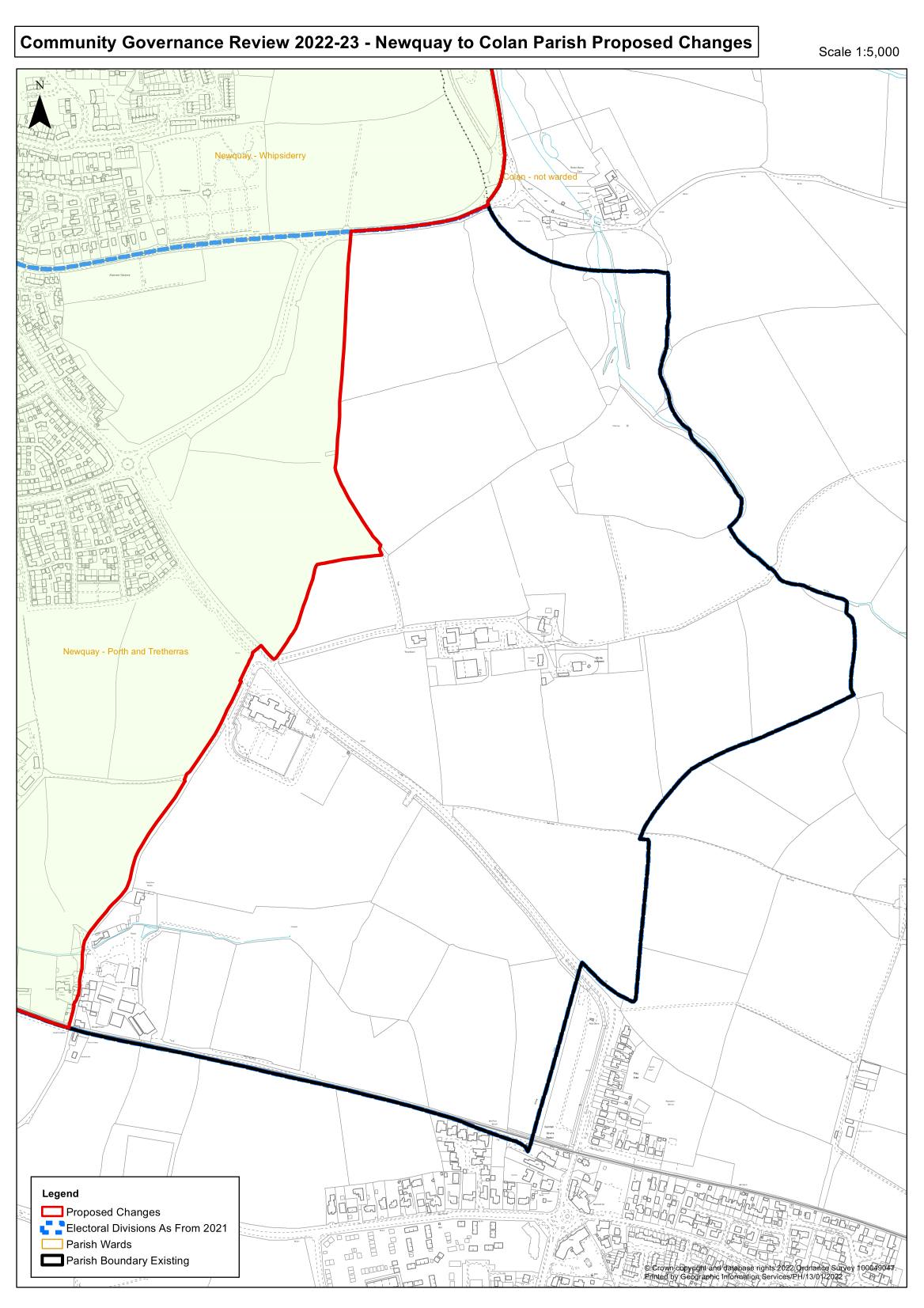
1. Boundary between Colan and Newquay – Land to the North and South of the A392
Background
Cornwall Council received a submission from Newquay Town Council that it wished to make changes to its southern boundary with Colan Parish, as per Map 1.0.
Colan Parish did not wish to make these changes and Cornwall Council heard concerns from residents of the Goldings development about the proposals.
Cornwall Council did not consider that a Boundary change in line with Map 1.0 was likely to better reflect the identity and interests of the area and secure more effective and convenient community governance. Cornwall Council agreed that a smaller boundary change in line with Map 1.1 was likely to better reflect the identity and interests of the area and secure more effective and convenient community governance and this was its draft recommendation which, after public consultation, was recommended by the Electoral Review Panel and approved by full Council. Therefore, the area edged red in Map 1.1 was transferred to Newquay Parish.
 |  |  |
| Map 1.0 - original proposal | Map 1.1 Change agreed 2020 | Map 1.2 Current consultation |
Following the public consultation, the Electoral Review Panel concluded that there were too many uncertainties to make a final decision with regards to the areas to the North and South of the A392 within the time available. The key uncertainties included the status of the plans for a housing estate in the area edged yellow shown in Map 1.2 and the views of residents already living in that area. Therefore, it was recommended that the decision be deferred. The recommendation to defer was approved by full Council for the reasons given by the Electoral Review Panel.
At the time of this consultation there is planning permission for the area shown edged yellow in Map 1.2.
A change in line with Map 1.2 would be subject to approval from the Local Government Boundary Commission for England.
2. Boundary between Colan and Newquay – Quintrell Downs
Background
Cornwall Council received a submission from Newquay Town Council that it wished to make changes to its eastern boundary with Colan Parish, as per Map 2.0 so as to transfer an area of land around the Quintrell Downs Green Gap and Trowellack Farm from Newquay to Colan Parish and Map 2.1 to transfer Rialton Wood from Colan to Newquay Parish. Colan Parish Council did not wish to make changes to its boundary but was willing to accept the transfer of Rialton Woods.
 |  |
| Map 2.0 Quintrell Downs | Map 2.1 Rialton Woods (change agreed 2020) |
Cornwall Council agreed that a boundary change in line with Map 2.1 was likely to better reflect the identity and interests of the area and secure more effective and convenient community governance and this was its draft recommendation which, after public consultation, was recommended by the Electoral Review Panel and approved by full Council. Therefore, the area edged red in Map 2.1 was transferred to Newquay parish and Colan parish respectively.
The Electoral Review Panel concluded that there were too many uncertainties to fully evaluate the area of Quintrell Downs shown edged red in Map 2.0 within the time available and recommended that the decision be deferred. The key uncertainties included the lack of Colan parish agreement to accept this transfer from Newquay parish, the views of residents living in this area and the status of planning applications for developments in this area.
The recommendation to defer was approved by full Council for the reasons given by the Electoral Review Panel.
Changes relating to Map 2.0 would be subject to approval from the Local Government Boundary Commission for England.
Consultation
To help inform the Council’s final decision on the changes under consideration, we asked for any additional views and information about these proposals, particularly with regards to any relevant changes that may have taken place in the area since March 2020 that impact on the proposals under consideration. People did not need to re-submit any views that they had already provided to us during the original consultation, as these would still be considered.
To provide their additional views, feedback or evidence with regards to these draft proposals, people were invited complete a feedback form, which was available online on this page or as hard copy on request. A printable reference copy is provided on this page. People were also able to email or post their response to us. The deadline for responses was 29 April 2022.
Outcomes
The feedback from this public consultation was considered at Constitution and Governance Committee meetings on 6th September 2022, 1st November 2022 and 12th January 2023 and informed their recommendations, which were raised and discussed at an Extraordinary meeting of the Council held on 31st January.
With regards to the proposals on this page, the decision was made to make No Changes to the current arrangements.